Showing posts with label route. Show all posts

Saturday, June 12, 2010

DAY SEVEN: VENTURA TO LOS ANGELES! WOOOO HOOOOO!


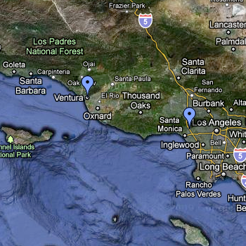
We're almost there! Today our trip south will take us through Ventura, Oxnard and Port Hueneme (pronounced Why-Knee-Me) and Malibu. Is that Mel Gibson I spy?! Or Barbie in her pink Corvette?!

We will see the military planes on display as you ride past the Naval Air Station on our way to Highway 1 also known as the Pacific Coast Highway (PCH). Once on PCH it's a straight shot down the coastline for about 20 miles. We will enjoy the southern California sights of surfers and beach goers as we pedal through Malibu on our way toward LA. We will complete our journey with a turn away from the coast and nice pedal through Santa Monica on our way to the Closing Ceremonies site.

Highlight of the day: The streets are peppered along the route on Day 7 with friends, family and well-wishers!

The other UNSPOKEN Highlight of the Day: TONIGHT WE GET TO SLEEP IN REAL BEDS! IN WEST HOLLYWOOD!


TODAY'S PROJECTED DISTANCE: 61.5 miles

Friday, June 11, 2010

DAY SIX: LOMPOC TO VENTURA!

Day Six begins on one of the prettiest roads on the entire route... You know, when it's not RAINING. Last year, the Day Six route was closed by the California Highway Patrol due to heavy rain, which caused a number of automobile accidents in the early morning.

But none of that this year! We hope.

We will pedal through vast expansive ranch lands with wildflower covered hills on both sides! As we ride toward the coast through the gorgeous Gaviota Pass we will be on US101. After lunch we will pass through the heart of Santa Barbara, Montecito and Carpinteria and on into Ventura where we camp at San Buenaventura State Beach.

Highlight of the day: Day Six is the best day for dolphin sightings! Tonight is also the annual candlelight vigil on the beach in Ventura. More on that later!


TODAY'S PROJECTED DISTANCE: 85.5 miles

Thursday, June 10, 2010

DAY FIVE: SANTA MARIA TO LOMPOC! RED DRESS DAY!


Day Five begins with a beautiful and scenic ride through the farmlands of Santa Maria. At the edge of town, we will enter one of Santa Barbara County's prettiest wine country roads. The scenery will be classic Central California with sprawling vineyards and ancient oak trees making the few challenging climbs along the way well worth the effort.

Lunch is located in the quaint tourist town of Solvang - a town founded by Danish immigrants. The authentic Danish architecture, thatched roofs, traditional windmills give the town an old world feel, making it a very popular cycling destination. Departing Solvang, we will pedal through Buellton, home of the world famous Pea Soup Andersen's and head into Lompoc on more beautiful and scenic wine country roads.

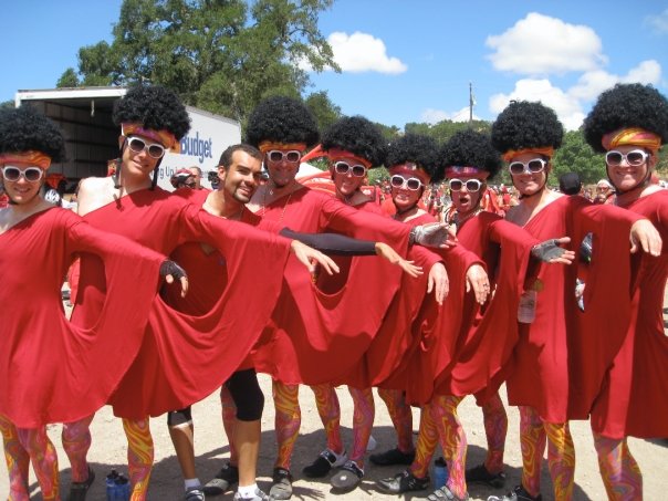
Highlight of the day: It's RED DRESS DAY!!!

(Just a note: This is the day that I ended up in the Emergency Room on ALC 7! Last year, no problems, but I'm hoping to avoid a repeat performance!)


TODAY'S PROJECTED DISTANCE: 67.7 miles... while wearing dresses.

Wednesday, June 9, 2010

DAY FOUR: PASO ROBLES TO SANTA MARIA!


The route on Day 4 has a little bit of everything - a feast for the eyes with stunning vistas and ocean views that give way to sprawling fields of farmland and even some quaint seaside towns. The route will wind along some remote and seldom-traveled roads as well as some congested town streets. Before lunch we will conquer the infamous Evil Twins. The Evil Twins are no fun! The name comes from the fact that once you reach the first summit, you have to ride back downhill a bit before riding UPHILL again to the second summit.


The views from the top of that second sister hill are nothing short of spectacular! The hills beyond the second hill seem to ripple and roll out toward the ocean just a few short miles away. From there we will ride back out to the coast and through the city of Pismo Beach and on into Preisker Park in the beautiful Central California city of Santa Maria. BUT... Not before stopping in the coastal town of Cayucos at the base of the mountain for Cheeseburgers with Dr. Vince and Team Dilly Dally!

Highlight of the day: Half Way to LA!!


TODAY'S PROJECTED DISTANCE: 97.7 miles

Tuesday, June 8, 2010

DAY THREE: KING CITY TO PASO ROBLES


TODAY IS THE QUADBUSTER! Sounds awful, huh?

Don't let the name scare you, though. Quadbuster is only a small part of the route on Day Three. We will pedal on VERY remote roads passing only a few small quaint stores, mostly later in the day. On ALC 7 we rode past the most expensive gas in the United States - no kidding - at $5.09 for Regular Unleaded!

Rest Stop 4 is at Mission San Miguel, one of California's 21 historic Missions. This is where I bought the crucifix for the Anglican rosary I created for last year's AIDS/LifeCycle event. The day ends as we ride into Paso Robles where we camp at the Mid State Fairgrounds. We dine inside the fairgrounds dining hall - what a treat! Indoor facilities! Highlight of the day: Lunch on Day Three is in the small town of Bradley where the local school hosts a BBQ to raise money for their field trip program. I'll gladly donate some money to the kids this year, but I'll bypass the burger line again this year to get back on the road I think.


TODAY'S PROJECTED DISTANCE: 66.7 miles

Monday, June 7, 2010

The view from DAY TWO: SANTA CRUZ TO KING CITY!


This is what the better part of Day Two ought to look like... I took this photo on ALC 7 -- Just before Scott C. wiped out and broke his shoulder. Scott is back on the ride this year. No more napping in ditches, buddy.

Beautiful, no?


Day Two is going to be 107.6 miles this year! This is a long mileage day with relatively flat terrain that will take us through the Salinas Valley, also known as Steinbeck Country (good thing I've read The Grapes of Wrath and Of Mice and Men, no?). The lushness of vineyards, strawberry and artichoke fields stretch as far as the eye can see in all directions. There are usually excellent tailwinds (except for one horrible spot where the tailwinds become CROSSWINDS!) along the roller coaster road (literally! Rolling hills with strong tailwinds pushing us home) that takes us into King City at the end of the day. Highlight of the day: Mission Soledad, the Water Stop location on Day 2 is one of the most historic and special destinations on the ride.


TODAY'S PROJECTED DISTANCE: 107.6 miles

Sunday, June 6, 2010

WELCOME TO DAY ONE! SAN FRANCISCO TO SANTA CRUZ!


Our AIDS/LifeCycle adventure begins as we ride out of the Cow Palace grounds in San Francisco immediately following Opening Ceremonies. The route on Day One offers some of the best scenery and cycling roads that San Mateo County has to offer. The stunning coastal views from hilltops to the ocean are truly Northern California at its best! Tailwinds prevail as we pedal along scenic CA Hwy 1 on our way to Harvey West Park in the City of Santa Cruz. Highlight of the day: The lunch stop on Day One offers a spectacular and breathtaking view of the ocean.

Day One offered three very moving experiences for me on ALC 7 and 8: The opening ceremonies, the crowds along the streets with memorials to family and friends lost to AIDS, and the beautiful views along the Pacific (pictured above).


TODAY'S PROJECTED DISTANCE: 79.4 miles

Saturday, June 5, 2010

A DAY ZERO PRIMER: WELCOME TO AIDS LIFECYCLE!

Tyler, Scott, and I want to thank all of you - our sponsors and supporters - for your contributions and messages of support over the last several months. Last year, Tyler and I kept a very active blog to help you experience AIDS LifeCycle as closely to way we experience it on the road.

Here it is again! While we've been blogging during our training, you're going to start to notice some changes in the way we post. Here's a little primer to the blog as you'll see it over the next few days.

Daily Route Summaries: Early each day, we'll post a route summary that offers a short description of the route, sometimes a photo or two, highlights for that day, and the total projected distance.

Gabcasts: Usually once or twice a day, we'll post an audio message that can be played through our blog. This is a chance to actually hear our voices and get a little bit of a quick update from the road.

Text Message Posts: We will post A LOT of short messages from the road in the form of text messages or short emails. These will be SHORT and SWEET, but will help give you an idea of what we're up to on the ride.

Photos and Videos: We will try to take some photos and video and post them from the road. You won't see too many of these, but we usually take a few and upload them. It's a pretty safe bet you'll see one the morning of Day Four when we hoist our bikes over our heads atop THE EVIL TWINS at the HALFWAY TO L.A. POINT.

Now, here's some overview information about the Route:

One of the many things that makes AIDS/LifeCycle such a unique and special event is the scenic route that takes us through the heart of California. Stunning views, historic destinations, and even the chance to spot dolphins frolicking off the coast are followed by a hero's welcome in the City of Angels. Although the route has been largely the same since the very first AIDS/LifeCycle, there are typically some changes from year to year.

There are seven days of riding, and each day is different. We’ll ride an average of 80 miles a day, over varying terrain. One day, we’ll be riding a flat route along the coast or through artichoke and strawberry fields, the next we might be riding through fog banks and foothills. The course is designed to be challenging but completely doable.

The starting points and destinations for each day are as follows:

DAY ONE: San Francisco to Santa Cruz
DAY TWO: Santa Cruz to King City
DAY THREE: King City to Paso Robles
DAY FOUR: Paso Robles to Santa Maria
DAY FIVE: Santa Maria to Lompoc
DAY SIX: Lompoc to Ventura
DAY SEVEN: Ventura to Los Angeles

Today is DAY ZERO (yeah, we really call it that)! We're in Orientation today, squaring away some final business and getting ready to hit the road! Keep checking in these next few days for new posts!

Friday, June 4, 2010

Elevation Profiles from AIDS LifeCycle 8

The route will probably be more or less the same this year. These are the elevation profiles from our route sheets. Look at some of those hills! You can click the image to zoom.

Saturday, May 22, 2010

Tomorrow's 80+ Mile Training Ride

Here's the rough route for our training route in the morning - with a long, fairly isolated stretch through the desert south of South Mountain. Lunch at Wildflower Baking Co. I'll need to modify this route to make it 80... It's only 70 right now.


View LONG Training in a larger map

Sunday, April 11, 2010

Data from the Paul Hulse Memorial Century Ride

We'll be posting a more complete description of the day's events early this week, but I wanted to share the map, elevation profile, and some data about the ride tonight before I hit the sack. Here you go!

(Click to View)


Starting Point: Santa Clarita, CA
Mid-Point: Ventura, CA
Ending Point: Santa Clarita, CA
Miles Completed: 103.9
Average Speed: 16.6 mph
Maximum Speed: 36 mph
Total Moving Time: 6:06
Total Ascent: 2,724 feet
Elevation Change from Lowest to Highest Point: 1,125 feet
Calories Burned: 5,600+
Total Flats: 2

Number of New Friendships: Too Many to Count!

Wednesday, March 17, 2010

The lay of the land - A day by day summary of the ALC route

DAY ONE: SAN FRANCISCO TO SANTA CRUZ
Our AIDS/LifeCycle adventure begins as we ride out immediately following Opening Ceremonies. The route on Day 1 offers some of the best scenery and cycling roads that San Mateo County has to offer. The stunning coastal views from hilltops to the ocean are truly Northern California at its best! Tailwinds prevail as we pedal along scenic CA Hwy 1 on our way to Harvey West Park in the City of Santa Cruz. Highlight of the day: The lunch stop on Day 1 offers a spectacular and breathtaking view of the ocean.

DAY TWO: SANTA CRUZ TO KING CITY
We rise and shine early on Day 2 to beat the Santa Cruz morning rush hour commute and get an early start on our second day in the saddle! This is a long mileage day with relatively flat terrain that will take us through the Salinas Valley, also known as Steinbeck Country. The lushness of vineyards, strawberry and artichoke fields stretch as far as the eye can see in all directions. There are usually excellent tailwinds along the roller coaster road that takes you into King City at the end of the day. Highlight of the day: Mission Soledad, the Water Stop location on Day 2 is one of the most historic and special destinations on the ride. Take a moment to enjoy the peaceful serenity of the Mission Chapel.

DAY THREE: KING CITY TO PASO ROBLES
Quadbuster. Don't let the name scare you. We are sure to make it to the top with our fellow cyclists (and perhaps a special guest) cheering us on and up! But Quadbuster is only a small part of the route on Day 3. We will pedal on remote roads passing only a few small quaint stores, mostly later in the day. Rest Stop 4 is at Mission San Miguel, one of California's 21 historic Missions. The day ends as we ride into Paso Robles where we camp at The Mid State Fairgrounds. We dine inside the fairgrounds dining hall - what a treat! Highlight of the day: Lunch on Day 3 is in the small town of Bradley where the local school hosts a BBQ to raise money for their field trip program.

DAY FOUR: PASO ROBLES TO SANTA MARIA
The route on Day 4 has a little bit of everything - a feast for the eyes with stunning vistas and ocean views that give way to sprawling fields of farmland and even some quaint seaside towns. The route will wind along some remote and seldom-traveled roads as well as some congested town streets. Before lunch we will conquer the infamous Evil Twins. The views from the top of that second sister hill are nothing short of spectacular and we may even find ourselves forgetting that we are pedaling uphill (yeah, right!). From there we will ride back out to the coast and through the city of Pismo Beach (Do I smell Cinnamon Rolls?) and on into Preisker Park in the beautiful Central California city of Santa Maria. Highlight of the day: Half Way to LA!! At the top of the second sister hill we will come upon a vista point turnout where we will have the opportunity to have our picture taken with the Half Way to LA sign!

DAY FIVE: SANTA MARIA TO LOMPOC
Day 5 begins with a beautiful and scenic ride through the farmlands of Santa Maria. At the edge of town, we will enter one of Santa Barbara County's prettiest wine country roads. The scenery will be classic Central California with sprawling vineyards and ancient oak trees making the few challenging climbs along the way well worth the effort. Lunch is located in the quaint tourist town of Solvang - a town founded by Danish immigrants. The authentic Danish architecture, thatched roofs, traditional windmills give the town an old world feel, making it a very popular cycling destination. Departing Solvang, we will pedal through Buellton, home of the world famous Pea Soup Andersen's and head into Lompoc on more beautiful and scenic wine country roads. Highlight of the day: Oh my, but don't you look just fabulous in that Red Dress!

DAY SIX: LOMPOC TO VENTURA
Day 6 begins on one of the prettiest roads on the entire route. We will pedal through vast expansive ranchlands with wildflower covered hills on both sides! As we ride toward the coast through the gorgeous Gaviota Pass we will be on US101. This is a well travelled freeway and caution should be practiced at all times along this portion of the route. After lunch we will pass through the heart of Santa Barbara, Montecito and Carpinteria and on into Ventura where we camp at San Buenaventura State Beach. Highlight of the day: Day 6 is the best bet for dolphin sightings!! Cast an eye to the sea and glimpse those playful creatures jumping in and out of the water as they frolic just off the coast.

DAY SEVEN: VENTURA TO LOS ANGELES
Almost there! Today our trip south will take us through Ventura, Oxnard and Port Hueneme (pronounced Why-Knee-Me) and Malibu. We will see the military planes on display as we ride past the Naval Air Station on our way to Highway 1 also known as the Pacific Coast Highway (PCH). Once on PCH it's a straight shot down the coastline for about 20 miles. We will enjoy the southern California sights of surfers and beach goers as we pedal through Malibu on our way toward LA. We will complete your journey with a turn away from the coast and nice pedal through Santa Monica on our way to the Closing Ceremonies site. Highlight of the day: The streets are peppered along the route on Day 7 with friends, family and well-wishers.


For more information about the route, go to http://www.aidslifecycle.org/life-on-the-event/route/